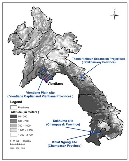
The field-based research has focused on three areas, namely: Vientiane/Vientiane Capital, Champasak and Bolikhamxay provinces.
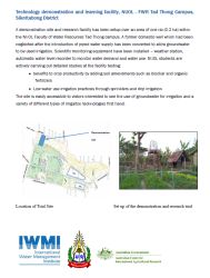
Technology demonstration and learning facility, NUOL – FWR Tad Thong Campus, Sikottabong District
Vientiane Plain
The first of the three focal areas is the Vientiane Plain, extending across the two neighboring provinces of Vientiane and Vientiane Capital. The significance of this site is reflected in the breadth of work carried out there. The Vientiane Plain, as one of seven major lowland plains of Lao PDR, is one of the most important agricultural production areas, with plans to further expand the area under irrigated agriculture, and which has not yet seriously considered making greater use of groundwater for irrigation. The proximity to large domestic markets (principally Vientiane) and high degree of rural electrification makes it worthwhile to examine if utilizable reserves of groundwater can be identified; particularly in areas remote from major surface water courses. The proximity to the Vientiane Capital City also made it logistically convenient for field work, and from the viewpoint of developing new irrigation technologies in particular, a necessary pre-requisite. The Vientiane Plain lies on the northern margin of the Khorat Plateau and knowledge of the hydrogeological systems of the Lao part of the Plateau is extremely limited relative to the more intensively studied work in Thailand (Landon, 2011). The widespread presence of marine deposits and poorly defined areas of low permeability impact the success of drilling efforts due to salinity and yield constraints.
Landon, M. (2011) Preliminary compilation and review of current information on groundwater monitoring and resources in the Lower Mekong River Basin. U.S. Geological Survey Report to the Mekong River Commission, Version Dated July 2011.
 |
 |
|
| Ekxang Village: Profile of a Community on the Vientiane Plains | Technology demonstration and learning facility, NUOL – FWR Tad Thong Campus, Sikottabong District |
Champasak Province
Studies have been carried out at Sukhuma and Pathoumphone districts in Champasak province through the work of one PhD student and one Masters student respectively. Sukhuma district is located on the southeastern margin of the Khorat Plateau and the lowland is one of the poorest and most drought prone of the lowland districts in Lao PDR (Vote et al., 2015). Mr. Sinxay Vongphachanh was awarded a John Allwright Fellowship in 2013 to undertake PhD studies at University Technology Sydney, beginning his studies in early 2015. His study is focusing on a quantitative hydrogeological assessment of the Huay Khamouan watershed, with particular emphasis on the surface water-groundwater interactions. The study at Pathoumphone District has focused on Khiat Ngong village where groundwater presents the only source of water supply, due to major water quality issues in relation to arsenic being raised by local authorities. The area is hydrogeologically quite distinct from Sukhuma (basalts overlying sandstone formation) and is situated adjacent to the on Beung Khiat Ngong wetland, which is Ramsar listed and of great environmental, social and cultural significance. Mr. Khamkieo Phommavong undertook a one year study of the groundwater resources in the village as part of his Masters and since the successful completion and defence of the Thesis has been carrying out a one-year research internship with IWMI to expand the study to the watershed scale to better reflect the groundwater – wetland interactions.
Vote, C., Newby, J., Phouyyavong, K., Inthavong, T. and Eberbach, P. (2015) Trends and perceptions of rural household groundwater use and the implications for smallholder agriculture in rain-fed Southern Laos. International Journal of Water Resources Development, 31(4):558-574.
Bolikhamxay Province
Opportunity to undertake scoping studies at Bolikhamxay province in central Laos was at the invitation of the Theun-Hinboun Power Company (THPC) through the Theun-Hinboun Expansion Project associated with the construction of the Nam Gnouang dam. Nam Gnouang River, a tributary of the Nam Theun, was dammed for power generation and has resulted in the resettlement of around 4,000 people into four new resettlement sites. The resettlement program seeks to ensure the resettled communities have an improved standard of living and sustainable livelihoods, including improved housing, household plots for vegetable gardens, fruit trees and small livestock, one hectare of rice fields and half a hectare of upland fields for cash crops and trees. THPC has invested in groundwater infrastructure to service domestic needs and approached the project team to explore if groundwater could also cost effectively provide irrigation water supplies for the lowland rice fields. The aim of groundwater for irrigation would be to increase agricultural productivity by providing water during the dry season and supplementing rainfall during the wet season.